Getting to Know the Model Inputs
HydroForecast uses a neural network-based approach that integrates diverse datasets—ranging from meteorological forecasts to satellite land surface observations and in situ sensor data. These inputs provide an up-to-date understanding of basin conditions, enabling the model to produce highly accurate inflow forecasts. Below, we’ve broken down the key model inputs by forecast type to give a clearer view of the data sources and their relevance.
Short-Term Forecast Inputs (10 days)
Meteorological Forecast Data
HydroForecast ingests data from multiple weather models to improve accuracy by leveraging similarities and differences between forecasts. Meteorological forecasts are incorporated every two hours into the model as data is available. For short-term models, inputs include:
- NOAA Global Ensemble Forecast System (GEFS) – Medium-range probabilistic forecasts; updated every 6 hours.
- NOAA Global Forecast System (GFS) – Deterministic forecasts for North America; updated every 6 hours. (Note: GFS is only included as a model input in North America but is accessible globally via the dashboard and API.)
- NOAA High-Resolution Rapid Refresh (HRRR) – Hourly updated, high-resolution forecasts for North America
- ECMWF High Resolution (HRES) – Deterministic global weather forecast; updated every 12 hours.
- Input Variables: Precipitation, temperature, solar radiation, humidity, wind speed, and pressure
Critically, we have found that by providing inputs from multiple forecasts simultaneously, the neural network is able to learn to use the similarities and differences between weather forecasts to produce an inflow forecast with higher accuracy than can be achieved with a single forecast on its own. Today, many sophisticated utilities address the problem of single-forecast reliability by having teams that create bespoke hybrid forecasts from multiple forecasts based on intuition. By providing multiple forecasts to the neural network directly, we are able to replicate this process with a data-driven, reliable, and flexible (i.e. add more forecasts as they become available) approach. We regularly review current and prospective inputs as part of our ongoing research and development.
Satellite Land Surface Data
Satellite observations provide the model with near real-time updates on hydrologically relevant land surface conditions.
- NASA VIIRS (Visible Infrared Imaging Radiometer Suite) – Daily observations of snow cover, vegetation vigor (NDVI) and minimum and maximum land surface temperature
- SNODAS – Daily observations of Snow Water Equivalent (North America only)
Geospatial Data
Static geospatial data helps the model understand topography basin characteristics which impact the flow of water in the basin.
- ERA5-Land Basin Characteristics – soil characteristics, land class, and other physical properties
- Merit DEM (Digital Elevation Model) – hydro-conditioned topography (mean basin elevation, slope)
In Situ Streamflow Data
Gauge observations are used for training, validation, and data assimilation. The model is updated every two hours with new observations as they become available.
- Public data from USGS in the United States
- Public data from ECCC in Canada
- Private customer data, if available
Seasonal Forecast Inputs (3 to 12 months)
Meteorological Forecast Data
Seasonal models combine long-term weather forecasts with historical reanalysis data to provide reliable projections over extended horizons.
- NOAA GEFS 35-Day Forecast – Medium-range ensemble forecast
- ERA5-Land Historical Precipitation and Temperature Reanalysis – data from 1980 to present
Satellite Land Surface Data
Similar to the short-term model, seasonal forecasts incorporate near real-time satellite data.
- NASA VIIRS (Visible Infrared Imaging Radiometer Suite) – daily observations of snow extent, vegetation vigor (NDVI) and land surface temperature
- SNODAS – Daily observations of Snow Water Equivalent (North America only)
 |
 |
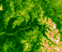 |
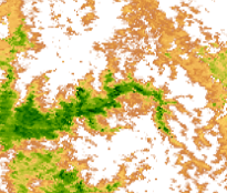
Visualizations of satellite vegetation and snow observations computed from NASA MODIS satellite data on three selected days during a spring snowmelt period. Healthy vegetation (dark green), bare ground (brown), and snow (white) demonstrate the spatially detailed and dynamic information these observations provide.
Geospatial Data
Static data provides foundational information about basin characteristics and topography.
- ERA5-Land Basin Characteristics – Soil characteristics, land class, and other static factors
- Merit DEM – Basin topography including mean elevation and slope
In Situ Streamflow Data
Gauge observations are used for training, validation, and data assimilation.
- Public data from USGS in the United States
- Public data from ECCC in Canada
- Private customer data if available
Experimental Data Sources (Not Yet Model Inputs)
We’re always exploring new data sources that have the potential to enhance HydroForecast’s accuracy and flexibility. While these sources are not yet integrated into the model, we’re making them visible in the dashboard to provide additional insights and allow for side-by-side comparisons with HydroForecast’s streamflow predictions.
WeatherNext Graph Forecast 🧪
- Google WeatherNext Graph is an AI-based global weather forecasting model developed by DeepMind that generates faster and more accurate weather predictions. Forecasts have a 10-day lead time and 6-hour temporal resolution. This experimental source will be displayed alongside other short-term input sources. While WeatherNext data is not yet a HydroForecast model input, displaying it in the HydroForecast dashboard allows customers to compare its weather forecasts with HydroForecast’s streamflow predictions in one place.
Experimental sources provide access to new sources and insights today while paving the way for deeper model integrations in the future as our team and customers review the value of each new source.
If you have any questions about HydroForecast model inputs or want to explore more about how the system uses these data sources, feel free to reach out!